Site Identification (GIS – Tool)
General
In the work package of the civil structure design (WP 5), sites with a high potential in the case of the chosen benchmark of low-head pumped hydro energy storages (LH-PHES) using the designed prototype of contra-rotating, variable-speed, reversible pump-turbines (CR-VS-RPT of WP2) in the North Sea are identified. The tool, which is based on GIS (geographic information system) offers interactive maps to explore the sites. The tool demonstrates the main findings of WP5 of the ALPHEUS project in user-friendly web maps.
Contributing Partners
| USTUTT | Site-identification for the German and French EEZ, development of the web tool |
| ADT | Development of the web tool |
| TUD | Site-identification for the Dutch, Belgian and Danish EEZ |
| UNITUS | Analysis of environmental conditions |
| TUB | Stake holder interviews |
| PAU | Wave impact |
Interactive Maps
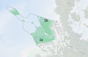
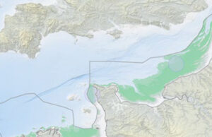
The PHES sites are identified in two different ways. On the one hand, the EEZ of Germany and France is scanned by an automated search routine developed by Prasasti et al. [1], which is a systematic analysis searching for optimized geospatial conditions and subtracting areas with use-specific constraints at the overall EEZ space. On the other hand, the sites identified in the Dutch EEZ, are evaluated by summing up a total suitability score of five different parameters.
Map Views
 |
 |
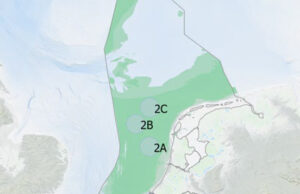 |
| Germany [2]-[5] | France [2]-[5] | The Netherlands [2]-[5] |
References
[1] E.B. Prasasti et al (2024). Available online at: https://doi.org/10.1016/j.rser.2023.114122 [Accessed 18 03 2024].
[2] EMODnet (2019). Bathymetry World Base Layer, version 1. Available online at: https://emodnet.ec.europa.eu/geonetwork/emodnet/eng/catalog.search#/metadata/386fe2aa-84c4-4cea-9e22-fcba4d5f2e75. [Accessed 18 03 2024].
[3] Flanders Marine Institute (2018). IHO Sea Areas, version 3. Available online at: https://www.marineregions.org/. https://doi.org/10.14284/323. [Accessed 18 03 2024].
[4] T. Chadwin, R. Klinger, V. Olaya and N. Dawson et al. qgis2web-Plugin. Available online at: https://plugins.qgis.org/plugins/qgis2web/. [Accessed 22 09 2023].
[5] OpenLayers (2024). Available online at: https://openlayers.org/. [Accessed 22 09 2023].
Contact
| USTUTT | Institute for Modelling Hydraulic and Environmental Systems (IWS), University of Stuttgart, Germany, K. Terheiden |
| ADT | Advanced Design Technology Ltd., London, United Kingdom, M. Zangeneh |
| TUD | Faculty of Civil Engineering and Geosciences (CEG), Delft University of Technology, The Netherlands, J. Bricker |
| UNITUS | Department of Ecological and Biological Sciences, Tuscia University, Italy, M. Marcelli |
| TUB | Leichtweiß-Institute for Hydraulic Engineering and Water Resources, Technical University Braunschweig, Germany, N. Goseberg |
| PAU | Laboratoire des Sciences de l’Ingénieur Appliquées à la Mécanique et au génie Electrique (SIAME), Université De Pau Et Des Pays De L’adour, France, V. Roeber |